Magpi users need to update their mobile app to version 6.2.1 by June 1st to take advantage of our upcoming new web application.
We were happy to see a recent publication touch extensively on the use of mobile devices to map human health: “What’s Your Status: Mapping Human Health” by Diana S. Sinton, the Executive Director of the University Consortium for Geographic Information Science [UCGIS], a non-profit, membership organization that supports a higher education community of practice around GIScience research and teaching.
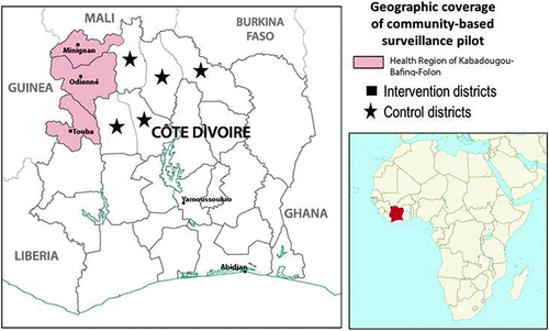
Disease surveillance in rural regions of many countries is poor, such that prolonged delays (months) may intervene between appearance of disease and its recognition by public health authorities. With Magpi, electronic surveillance not only provided a real-time map of the health status of children with established Nodding Syndrome but also revealed previously unknown children with head nodding.
In 2017, Kenya’s presidential election result was disputed by the opposition. Unlike previous elections, Kenya’s Elections Observations Group (ELOG), consisting of civil society and faith-based organizations, had equipped about a third of its 5,700 observers with the ability to report election results by SMS.
The World Health Organization (WHO) has used Magpi in multiple countries for years, and in its polio program documented how it utilized Magpi to implement a real-time data system, with no programmers or technicians – taking advantage of Magpi’s simplicity to achieve impressive results and keep costs low.
As newer technologies come on board, it’s not that older technologies immediately disappear. Paper-based data collection will continue for some organizations, while other embrace a mix of apps, SMS, voice and machine reporting. Magpi make sure that all of those options are easy, accessible, and affordable for every organization.